01The Black Hills as an Uplifted Island in a Prairie Sea
The Black Hills rise from the surrounding plains abruptly enough that you feel the transition before you understand it. Driving west out of Rapid City, the land lifts, the grass shortens and then disappears into ponderosa pine, and within a few miles the road is threading between rock walls that were laid down before the first complex animals existed on Earth. The hills are not a range in the conventional sense — no fault-driven escarpment, no volcanic eruption. They are an island of very old stone that the land around them simply wore away.
The structure is a dome. Over roughly sixty million years, during the same broad period of crustal compression that built the Rockies to the west, a mass of Precambrian granite and metamorphic rock pushed upward through the younger sedimentary layers that blanketed the Great Plains. Erosion then stripped those younger layers from the top of the dome, exposing the core. What remains today is a bull's-eye of ancient rock at the center, surrounded by concentric rings of progressively younger formation — limestone, sandstone, shale — each tilted outward from the uplift like the layers of an onion sliced in half. The whole structure is roughly a hundred miles long and about fifty miles across at its widest, oriented roughly north to south.
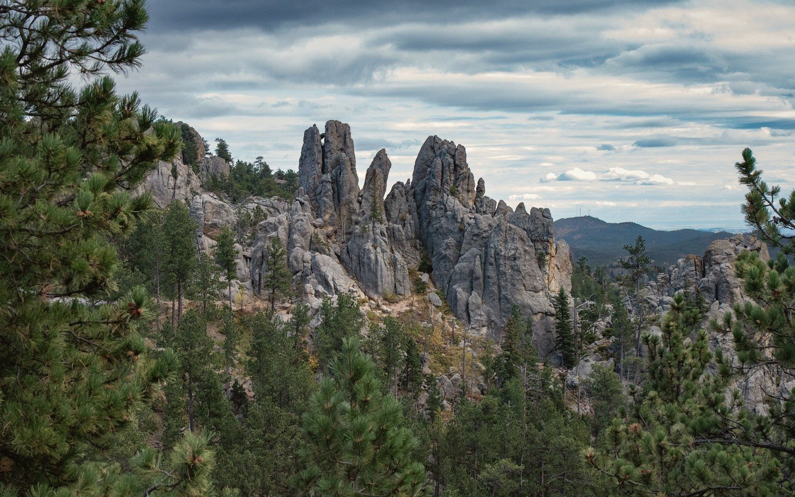
At the center of that bull's-eye, the rock is genuinely ancient. The Harney Peak Granite — now formally named the Harney Peak Leucogranite — crystallized deep in the crust somewhere around 1.7 to 1.6 billion years ago, during a period of mountain building that geologists call the Trans-Hudson Orogeny. The peaks, spires and domes you see in the core of the hills are that granite, exposed and shaped by weathering over hundreds of millions of years. Harney Peak itself, at just over 7,200 feet the highest point in South Dakota and the highest summit in the United States east of the Rockies, is made of it. So are the cathedral spires of the Needles, the granite domes of Custer State Park, and the abrupt rocky summits that give the range its visual character from a distance.
By the numbers
02What the Rings Tell You
Understanding the dome structure is practical knowledge for anyone moving through the hills on foot or by road. The terrain you encounter depends almost entirely on which ring of rock you happen to be standing on, and those rings shift over surprisingly short horizontal distances.
The terrain you encounter depends almost entirely on which ring of rock you happen to be standing on, and those rings shift over surprisingly short horizontal distances.
The outermost ring is limestone — specifically the Pahasapa Limestone, a marine deposit laid down roughly 350 million years ago when a shallow inland sea covered this part of the continent. This is the rock of the caves. Wind Cave, in the southern hills, and Jewel Cave to the northwest are both dissolved into the Pahasapa formation, and both rank among the longest cave systems in the world. Limestone dissolves in mildly acidic groundwater, creating the passages, chambers and distinctive boxwork formations that make these caves remarkable. On the surface, the limestone belt is relatively open and grassy — the rock weathers to thin soil, drainage tends to disappear underground, and the landscape is gentler and more rolling than the granite core.
Inward from the limestone, the next ring is the Deadwood Formation and the overlying Minnekahta Limestone and Spearfish Formation, a sequence of red and purple shales and sandstones that produce the red valleys for which the area is locally known. The Spearfish Formation in particular — a sequence of soft red shales and evaporites — erodes quickly, forming the wide swales and red-soiled hollows that sit between the limestone hogback ridges on the outer edge and the harder rock of the core. Spearfish Canyon, carved by Spearfish Creek through the limestone and into the underlying shales, cuts right through several of these rings in sequence. Driving up the canyon from the town of Spearfish, you pass from the plains, through the limestone walls of the outer hogback, and then into the heart of the range — a rapid geological transit that takes only a few miles.
The transition inward to the granite core is marked by a change in forest as much as in rock type. Ponderosa pine dominates the limestone and shale zones. As the granite appears underfoot, the forest composition shifts — white spruce, paper birch and aspen become more common in sheltered hollows, and exposed granite domes carry only the thinnest soil, with rock outcrop increasingly dominant. The granite weathers into rounded forms on broad summits and breaks into angular joint-controlled blocks and spires where fracture patterns allow. The Needles, the most dramatic example, are fins and towers of coarse-grained leucogranite standing clear of the surrounding slope — the product of differential weathering along vertical joint sets.
03Island Effects: Ecology, Water and Isolation
Because the hills project well above the surrounding plains, they intercept moisture that the prairies do not receive. The core receives considerably more annual precipitation than the surrounding grasslands, and snow lingers longer at elevation. This moisture differential is what sustains the forest. The ponderosa pine woodland that covers most of the hills would be impossible at lower elevations on the surrounding plains — the hills create their own microclimate, and that microclimate creates the dark canopy that gave the range its Lakota name, Pahá Sápa, meaning hills that are black.
The isolation of the hills matters ecologically in ways that are still being studied. The Black Hills are a genuine ecological island: a forested, montane environment surrounded by semi-arid grassland, separated from the nearest comparable habitat in the Rocky Mountain system by several hundred miles. Species that arrived during cooler, wetter periods — when forest corridors connected the hills to the broader mountain West — now persist in the hills as isolated populations. White spruce, which is at the southeastern edge of its North American range in the Black Hills, is one example. Pronghorn move easily across the surrounding plains and into the hills seasonally, but other species find the surrounding matrix of grassland a genuine barrier. The hills support a disjunct population of elk that was extirpated from the region and then reintroduced in the early twentieth century; the herd in Custer State Park is now one of the largest publicly managed elk herds in the country.
Water behaves differently here than anywhere else in South Dakota. The hills are a major recharge zone for the regional aquifer system. Rain and snowmelt infiltrate the limestone and sandstone formations, moving into the Madison Aquifer — the same aquifer that supplies much of the surrounding plains region through artesian wells. Springs emerge along the contact zones between permeable and impermeable rock units, and the streams that originate in the hills — the Cheyenne River, Spearfish Creek, the Belle Fourche River — carry water out onto the surrounding plains that would otherwise receive very little surface flow. The hills are, hydrologically, the engine that drives a much larger system.
Bear Butte, standing isolated on the northeastern plains just outside the main mass of the hills, is a remnant of that uplift story — a laccolith, a body of igneous rock that intruded between sedimentary layers and domed them upward without breaking through to the surface, then was left standing as the surrounding softer rock eroded away. It is geologically related to the Black Hills uplift but geographically separate, a lone signal on the plains that marks how far the forces that built the hills once extended.
The practical takeaway for anyone exploring the hills is that the geology is readable on the ground. The rock underfoot changes color, texture and hardness as you move through the rings of the dome. The limestone zone sounds hollow in places, drains quickly and supports caves. The red valley shales are soft, slippery when wet and deeply colored. The granite core is hard, pale gray to pink, dotted with quartz and feldspar crystals large enough to see clearly, and it weathers into the knobby, rounded high country that defines the hills from above. Pay attention to what is underfoot and the map of the dome assembles itself without any further explanation needed.
Elevations, ages and distances here are approximate and given as published. Ground conditions change; the terrain descriptions do not.
04Ground named in this piece
Harney Peak (Harney Peak Leucogranite)
The Black Hills
highest summit in South Dakota; granite core of the Black Hills
Pahasapa Limestone
The Black Hills
marine limestone unit forming the cave belt around the dome
Bear Butte
The Black Hills
isolated laccolith on the northeastern plains, geologically related to the Black Hills uplift
Spearfish Formation
The Black Hills
soft red shales and evaporites forming the red valleys of the hills